


Tourris - La pyramide de Cassini

soca
User
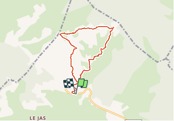

Length
7.4 km

Max alt
779 m

Uphill gradient
362 m
Km-Effort
12.2 km

Min alt
404 m

Downhill gradient
366 m
Boucle
Yes
Creation date :
2020-09-11 21:34:02.857
Updated on :
2020-09-11 21:36:15.507
2h29
Difficulty : Easy

FREE GPS app for hiking
 SityTrail
IGN / Geographical institutes
SityTrail Plus
The world is yours!
About
Trail Walking of 7.4 km to be discovered at Provence-Alpes-Côte d'Azur, Var, Le Revest-les-Eaux. This trail is proposed by soca.
Positioning
Country:
France
Region :
Provence-Alpes-Côte d'Azur
Department/Province :
Var
Municipality :
Le Revest-les-Eaux
Location:
Unknown
Start:(Dec)
Start:(UTM)
738895 ; 4785807 (31T) N.
Comments